
Gracias por apoyar a este sitio ❤️
Haz una donación
Haz una donación
Mapa topográfico Gangapur
Haga clic en el mapa para ver la altitud.
Gracias por apoyar a este sitio ❤️
Haz una donación
Haz una donación
Gangapur
Gangapur City is located in the eastern part of Rajasthan; it is situated 140 km from Jaipur (The Capital of Rajasthan). The city's area is about 25 km² and has an average elevation of 1,624 feet.
Gracias por apoyar a este sitio ❤️
Haz una donación
Haz una donación
Acerca de este mapa
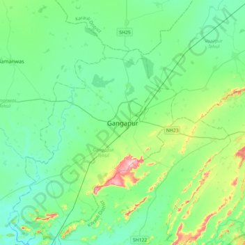
Nombre: Mapa topográfico Gangapur, altitud, relieve.
Altitud media: 265 m
Altitud mínima: 220 m
Altitud máxima: 432 m
Gracias por apoyar a este sitio ❤️
Haz una donación
Haz una donación