
Haz una donación
Mapa topográfico Kottur
Haga clic en el mapa para ver la altitud.
Haz una donación
Acerca de este mapa
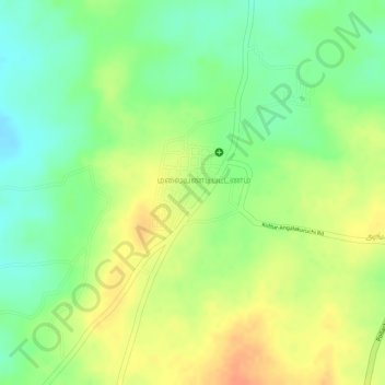
Nombre: Mapa topográfico Kottur, altitud, relieve.
Lugar: Kottur, Pollachi, Coimbatore District, Tamil Nadu, India (10.52596 76.97370 10.54753 76.98584)
Altitud media: 296 m
Altitud mínima: 273 m
Altitud máxima: 317 m
Haz una donación
Otros mapas topográficos
Haga clic en un mapa para ver su topografía, su altitud y su relieve.
Pollachi
India > Tamil Nadu > Pollachi
Pollachi is located at 10°39′43″N 77°00′23″E / 10.662°N 77.0065°E / 10.662; 77.0065. It has an average elevation of 293 metres (961 ft). Aliyar river passes about 10 kilometres (6.2 mi) away from the town and the town receives rainfall from Southwest monsoon due to the presence of Palghat gap.
Altitud media: 289 m
Haz una donación
Haz una donación
Pollachi
India > Tamil Nadu > Pollachi
Pollachi is located at 10°39′43″N 77°00′23″E / 10.662°N 77.0065°E / 10.662; 77.0065 near the center of the South Indian Peninsula, surrounded by Western Ghats. It has an average elevation of 293 metres (961 ft) on the banks of Aliyar river. The area is hilly and rocky, drained by several…
Altitud media: 289 m