
Mapa topográfico Imphal East
Mapa interactivo
Haga clic en el mapa para ver la altitud.
Acerca de este mapa
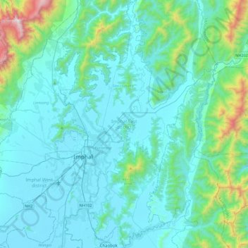
Nombre: Mapa topográfico Imphal East, altitud, relieve.
Lugar: Imphal East, Manipur, India (24.65151 93.89542 25.05120 94.13485)
Altitud media: 982 m
Altitud mínima: 767 m
Altitud máxima: 2,498 m
Imphal East District came into existence on 18-06-1997 with its headquarters at Porompat occupying the eastern part of Imphal District. The total area of District is 497 km2. approximately. The District is situated at an altitude 790 metres above the M.S. Level. The climate of the District is salubrious and Monsoon is tropical. The minimum temperature goes down to 0.6 degree Celsius in winter and 41 degree Celsius in summer. It has no rail network and hence communication is entirely dependent on roads except Jiribam District bordering Cachar District of Assam where there is a railhead. As of 2017, A new rail line is under construction and a railway station will be operational by 2019. The District is connected with N.H. 39, N.H. 53 and N.H. 150.
Otros mapas topográficos
Haga clic en un mapa para ver su topografía, su altitud y su relieve.
Leimakhong
India > Manipur > Saitu-Gamphazol
Leimakhong, Saitu-Gamphazol, Kangpokpi District, Manipur, 795136, India
Altitud media: 967 m
Koubru
India > Manipur > Saitu-Gamphazol
Koubru, Saitu-Gamphazol, Kangpokpi, Manipur, India
Altitud media: 2,146 m
Imphal
India > Manipur > Lamphelpat
Imphal, Lamphelpat, Imphal West District, Manipur, 795001, India
Altitud media: 861 m
Iril River
Iril River, Sawombung, Imphal East, Manipur, 795118, India
Altitud media: 992 m
Manipur River
India > Manipur > Chakpikarong
Manipur River, Chakpikarong, Chandel, Manipur, India
Altitud media: 964 m
Khuga Dam
India > Manipur > Churachandpur
Khuga Dam, Churachandpur, Manipur, India
Altitud media: 849 m
Lamphelpat
India > Manipur > Lamphelpat
Lamphelpat, Imphal West, Manipur, 795002, India
Altitud media: 828 m
Nambul River
Nambul River, Imphal, Lamphelpat, Imphal West, Manipur, 795001, India
Altitud media: 784 m
Loktak Lake
India > Manipur > Nambol block > Karang
Loktak Lake, Karang, Nambol block, Bishnupur District, Manipur, India
Altitud media: 771 m