
Gracias por apoyar a este sitio ❤️
Haz una donación
Haz una donación
Mapa topográfico Mount Sungay
Haga clic en el mapa para ver la altitud.
Gracias por apoyar a este sitio ❤️
Haz una donación
Haz una donación
Mount Sungay
Mount Sungay is the eastern end of the Tagaytay Range, or more commonly known as the Tagaytay Ridge, a 32-kilometre (20 mi) ridge located at the southern part of the province with elevations averaging about 600 m (2,000 ft) above sea level. The ridge stretches west-southwest from Mount Sungay to Mount Batulao in Batangas province.
Gracias por apoyar a este sitio ❤️
Haz una donación
Haz una donación
Acerca de este mapa
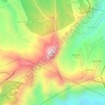
Nombre: Mapa topográfico Mount Sungay, altitud, relieve.
Altitud media: 501 m
Altitud mínima: 264 m
Altitud máxima: 728 m
Gracias por apoyar a este sitio ❤️
Haz una donación
Haz una donación
Otros mapas topográficos
Haga clic en un mapa para ver su topografía, su altitud y su relieve.