
Gracias por apoyar a este sitio ❤️
Haz una donación
Haz una donación
Mapa topográfico Katargam Taluka
Haga clic en el mapa para ver la altitud.
Gracias por apoyar a este sitio ❤️
Haz una donación
Haz una donación
Acerca de este mapa
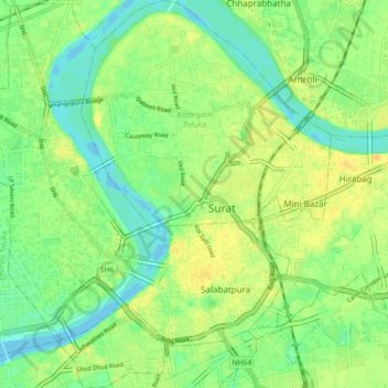
Nombre: Mapa topográfico Katargam Taluka, altitud, relieve.
Lugar: Katargam Taluka, Surat, Gujarat, India (21.17013 72.79314 21.25470 72.85721)
Altitud media: 13 m
Altitud mínima: -4 m
Altitud máxima: 27 m
Gracias por apoyar a este sitio ❤️
Haz una donación
Haz una donación
Otros mapas topográficos
Haga clic en un mapa para ver su topografía, su altitud y su relieve.
Surat
India > Gujarat > Katargam Taluka > Surat
Surat is a port city situated on the banks of the Tapi river. Damming of the Tapi caused the original port facilities to close; the nearest port is now in the Magadalla and Hazira area of Surat Metropolitan Region.It has famous beach called 'Dumas Beach' located in Hazira. The city is located at 21°10′N…
Altitud media: 11 m