
Haz una donación
Mapa topográfico High Etherley
Haga clic en el mapa para ver la altitud.
Haz una donación
Acerca de este mapa
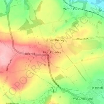
Nombre: Mapa topográfico High Etherley, altitud, relieve.
Altitud media: 149 m
Altitud mínima: 70 m
Altitud máxima: 228 m
Haz una donación
Otros mapas topográficos
Haga clic en un mapa para ver su topografía, su altitud y su relieve.
Haz una donación
Haz una donación
Haz una donación
South Agnew Plantation
United Kingdom > England > County Durham > Newton Aycliffe
Altitud media: 100 m
Haz una donación
Haz una donación
Haz una donación
Haz una donación
Haz una donación
Haz una donación
Haz una donación
Haz una donación
Haz una donación
Haz una donación
Haz una donación
Haz una donación
Haz una donación
Haz una donación
Haz una donación
Haz una donación
Haz una donación
Haz una donación
Oakey's Park
United Kingdom > England > County Durham > Stanley > West Shield Row Villas
Altitud media: 182 m
Haz una donación
Bishop Middleham Quarry Nature Reserve
United Kingdom > England > County Durham > Bishop Middleham
Altitud media: 115 m
Tunstall Reservoir
United Kingdom > England > County Durham > Wolsingham
The reservoir was created for the Weardale and Shildon District Waterworks Company, with construction of the dam between 1873 and 1879.[2][3] The earth embankment dam was built across the valley of Waskerley Beck, and measures 1,020 feet (310 m) long and 82 feet (25 m) high. It was constructed with a puddle…
Altitud media: 288 m
Haz una donación
Haz una donación
Haz una donación