
Mapa topográfico Lawrenceburg
Mapa interactivo
Haga clic en el mapa para ver la altitud.
Acerca de este mapa
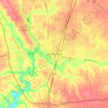
Nombre: Mapa topográfico Lawrenceburg, altitud, relieve.
Altitud media: 278 m
Altitud mínima: 213 m
Altitud máxima: 317 m
The city of Lawrenceburg has a total area of 12.6 square miles (33 km2). It is the largest city on the state line between Chattanooga and Memphis. Located on the southern Highland Rim, Lawrence County and Lawrenceburg are set atop of a large mountain plateau of the Appalachian Mountain range with elevations ranging between 810 feet (250 m) to over 1,120 feet (340 m). Map of the Appalachian Mountain Range.