
Mapa topográfico Caswell Beach
Mapa interactivo
Haga clic en el mapa para ver la altitud.
Caswell Beach
Roughly halfway distant from Wilmington, North Carolina and Myrtle Beach, South Carolina, Caswell Beach is located on the east end of Oak Island. This island is the easternmost of the South Brunswick Islands which were formed in the late 1930s by the construction of the Intracoastal Waterway (ICW) which was dredged from Southport, NC at the mouth of the Cape Fear River through coastal sounds and marshes to the Little River in South Carolina. Elevations in the town range from sea level to approximately 25'while the town has a total area of 4.1 square miles (10.5 km2), of which 2.9 square miles (7.6 km2) is land.
Acerca de este mapa
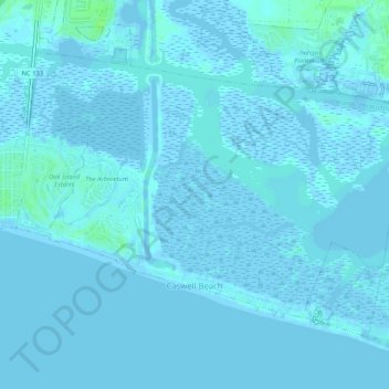
Nombre: Mapa topográfico Caswell Beach, altitud, relieve.
Altitud media: 1 m
Altitud mínima: -4 m
Altitud máxima: 9 m
Otros mapas topográficos
Haga clic en un mapa para ver su topografía, su altitud y su relieve.
Bald Head Island
United States > North Carolina > Brunswick County > Bald Head Island
Altitud media: 3 m
Southport
United States > North Carolina > Brunswick County > Southport > Southport
Altitud media: 3 m
Sea Trail Plantation
United States > North Carolina > Brunswick County > Sea Trail Plantation
Altitud media: 6 m