
Mapa topográfico Georgetown
Mapa interactivo
Haga clic en el mapa para ver la altitud.
Acerca de este mapa
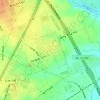
Nombre: Mapa topográfico Georgetown, altitud, relieve.
Lugar: Georgetown, Williamson County, Texas, United States (30.66650 -97.66000 30.67646 -97.64954)
Altitud media: 219 m
Altitud mínima: 200 m
Altitud máxima: 236 m
The city is located on the northeastern edge of Texas Hill Country. Portions of Georgetown are located on either side of the Balcones Escarpment, a fault line in which the areas roughly east of IH-35 are flat and characterized by having black, fertile soils of the Blackland Prairie, and the west side of the escarpment which consists mostly of hilly, karst-like terrain with little topsoil and higher elevations and which is part of the Texas Hill Country. Inner Space Cavern, a large cave, is a major tourist attraction found on the south side of the city, just west of Interstate 35, and is a large-scale example of limestone karst formations.