
Gracias por apoyar a este sitio ❤️
Haz una donación
Haz una donación
Mapa topográfico New Haven
Haga clic en el mapa para ver la altitud.
Gracias por apoyar a este sitio ❤️
Haz una donación
Haz una donación
Acerca de este mapa
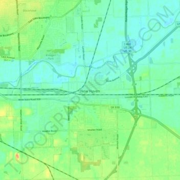
Nombre: Mapa topográfico New Haven, altitud, relieve.
Lugar: New Haven, Allen County, Indiana, 46774, United States (41.03314 -85.07784 41.11440 -84.94781)
Altitud media: 237 m
Altitud mínima: 223 m
Altitud máxima: 261 m
Gracias por apoyar a este sitio ❤️
Haz una donación
Haz una donación
Otros mapas topográficos
Haga clic en un mapa para ver su topografía, su altitud y su relieve.
Gracias por apoyar a este sitio ❤️
Haz una donación
Haz una donación
Gracias por apoyar a este sitio ❤️
Haz una donación
Haz una donación
Fort Wayne
United States > Indiana > Allen County > Fort Wayne
The first settlement started in 1815. In 1819, the military garrison abandoned the fort and moved to Detroit. In 1822, a federal land office opened to sell land ceded by local Native Americans by the Treaty of St. Mary's in 1818. Platted in 1823 at the Ewing Tavern, the village became an important frontier…
Altitud media: 248 m