
Mapa topográfico The Villages at Mount Hood
Mapa interactivo
Haga clic en el mapa para ver la altitud.
Acerca de este mapa
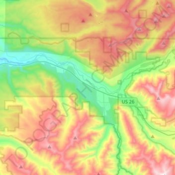
Nombre: Mapa topográfico The Villages at Mount Hood, altitud, relieve.
Altitud media: 808 m
Altitud mínima: 256 m
Altitud máxima: 1,521 m
Otros mapas topográficos
Haga clic en un mapa para ver su topografía, su altitud y su relieve.
Wemme
United States > Oregon > Clackamas County > Welches
Wemme, Welches, Clackamas County, Oregon, 97067, United States
Altitud media: 494 m