
Haz una donación
Mapa topográfico Greenhow Hill
Haga clic en el mapa para ver la altitud.
Haz una donación
Greenhow Hill
The village is about 3 miles (4.8 km) west of Pateley Bridge on the road heading towards Grassington, and is mainly in the civil parish of Bewerley. However, the western end of the village lying to the west of Kell Dyke, commonly known as Craven Cross, lies within the civil parish of Appletreewick in Craven. It is one of the highest villages in Yorkshire, at an altitude of between 1,310 and 1,380 feet (400 and 420 m), and one of the few villages in the United Kingdom lying at over 1,300 feet (400 m).
Haz una donación
Acerca de este mapa
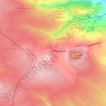
Nombre: Mapa topográfico Greenhow Hill, altitud, relieve.
Altitud media: 358 m
Altitud mínima: 176 m
Altitud máxima: 431 m
Haz una donación
Otros mapas topográficos
Haga clic en un mapa para ver su topografía, su altitud y su relieve.
Haz una donación
Haz una donación
Haz una donación
Haz una donación
Harrogate
United Kingdom > England > North Yorkshire
Harrogate is situated on the edge of the Yorkshire Dales, with the Vale of York to the east and the upland Yorkshire Dales to the west and north-west. It has a dry and mild climate, typical of places in the rain shadow of the Pennines. It is on the A59 from Skipton to York. At an altitude of between 100 and…
Altitud media: 131 m
North York Moors National Park
United Kingdom > England > North Yorkshire
As part of the United Kingdom, the North York Moors area generally has warm summers and relatively mild winters. Weather conditions vary from day to day as well as from season to season. The latitude of the area means that it is influenced by predominantly westerly winds with depressions and their associated…
Altitud media: 110 m
Haz una donación
Thimbleby & Osmotherly Show field
United Kingdom > England > North Yorkshire > Thimbleby
Altitud media: 152 m
Haz una donación
River Aire
United Kingdom > England > North Yorkshire > Craven District > Malham > Hanlith
Altitud media: 237 m
Haz una donación
Haz una donación
Haz una donación
Haz una donación
Haz una donación
Haz una donación
Haz una donación
Haz una donación
Haz una donación
Haz una donación
Scarborough
United Kingdom > England > North Yorkshire
The climate is temperate with mild summers and cool, windy, winters. The hottest months of the year are July and August, with temperatures reaching an average high of 17 °C and falling to 11 °C at night. The average daytime temperatures in January are 4 °C, falling to 1 °C at night. The station's elevation…
Altitud media: 50 m
Haz una donación
Haz una donación
Haz una donación
Haz una donación
Farlington
United Kingdom > England > North Yorkshire
The village is at an elevation of 123 feet (37 m) above sea level at its highest point. The nearest settlements are Stillington 2 miles (3.2 km) to the west; Sheriff Hutton 2.3 miles (3.7 km) to the east-south-east; Brandsby-cum-Stearsby 2.6 miles (4.2 km) to the north and Sutton-on-the-Forest 2.71 miles (4.36…
Altitud media: 40 m
Haz una donación
Thornton-le-Street
United Kingdom > England > North Yorkshire
The village is located between the west bank of the Cod Beck and the A168 road between Thirsk and Northallerton. Within a radius of 2.5 miles (4 km) can be found the settlements of Thornton-le-Moor, Borrowby, Knayton, Upsall, South Kilvington, Newsham and South Otterington. The mean elevation in the village is…
Altitud media: 50 m
Haz una donación
River Derwent
United Kingdom > England > North Yorkshire
Rainfall and climate conditions vary slightly across the Derwent catchment area due to the topography. Annual rainfall ranges from averages of 600 millimetres (24 in) at Barmby Barrage to over 1,100 millimetres (43 in) at its source on the North York Moors.
Altitud media: 66 m
Haz una donación
Haz una donación
Haz una donación