
Haz una donación
Mapa topográfico General Tinio
Haga clic en el mapa para ver la altitud.
Haz una donación
General Tinio
Farming is the livelihood of majority of the residents. Even though located at the foot of the Sierra Madre Mountain Ridges, the topography is generally plain ideal to agricultural products such as palay and vegetables. A number of poultry broiler contract growers are located in the municipality. Other industries include furniture and fixtures, backyard poultry, cattle and livestock, vegetable production and minor agricultural livelihoods like duck raising. "Ikmo" or betel leaves production is one dying symbol of the town. The practice of chewing betel leaves by the older generation was not adopted by the younger generation even though of its reported natural anti-cancer formula.
Haz una donación
Acerca de este mapa
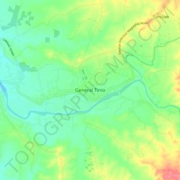
Nombre: Mapa topográfico General Tinio, altitud, relieve.
Lugar: General Tinio, Nueva Ecija, Central Luzon, 3104, Philippines (15.31013 121.00980 15.39013 121.08980)
Altitud media: 54 m
Altitud mínima: 28 m
Altitud máxima: 104 m
Haz una donación
Otros mapas topográficos
Haga clic en un mapa para ver su topografía, su altitud y su relieve.
Talavera
The municipality's terrain is relatively flat, with slope ranging from 0 to 3%. Due to the flat topography, the land is suited for agricultural, commercial or industrial development. It is bordered by Cabanatuan, Llanera, Muñoz, Aliaga, General Mamerto Natividad, Santo Domingo and San Jose.
Altitud media: 49 m
Haz una donación