
Mapa topográfico Fort Mitchell
Mapa interactivo
Haga clic en el mapa para ver la altitud.
Acerca de este mapa
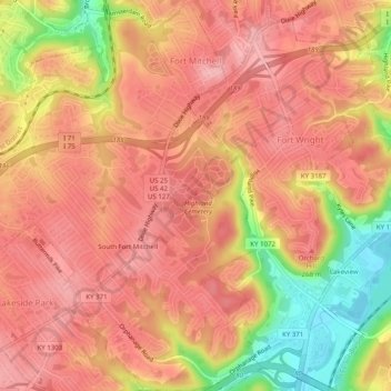
Nombre: Mapa topográfico Fort Mitchell, altitud, relieve.
Lugar: Fort Mitchell, Kenton County, Kentucky, United States (39.02686 -84.58034 39.06546 -84.53963)
Altitud media: 235 m
Altitud mínima: 146 m
Altitud máxima: 275 m
Otros mapas topográficos
Haga clic en un mapa para ver su topografía, su altitud y su relieve.
Fort Wright
United States > Kentucky > Kenton County
Fort Wright, Kenton County, Kentucky, United States
Altitud media: 219 m
Pride Park
United States > Kentucky > Kenton County > Taylor Mill
Pride Park, Taylor Mill, Kenton County, Kentucky, United States
Altitud media: 237 m
Piner
United States > Kentucky > Kenton County
Piner, Kenton County, Kentucky, 41163, United States
Altitud media: 251 m
Covington
United States > Kentucky > Kenton County
Covington, Kenton County, Kentucky, United States
Altitud media: 215 m
Independence
United States > Kentucky > Kenton County
Independence, Kenton County, Kentucky, 41051, United States
Altitud media: 254 m
Erlanger
United States > Kentucky > Kenton County
Erlanger, Kenton County, Kentucky, 41018, United States
Altitud media: 258 m
Daniel Carter Beard Boyhood Home
United States > Kentucky > Kenton County > Covington
Daniel Carter Beard Boyhood Home, Licking Riverside Historic District, Covington, Kenton County, Kentucky, United States
Altitud media: 157 m
Taylor Mill
United States > Kentucky > Kenton County
Taylor Mill, Kenton County, Kentucky, 41015, United States
Altitud media: 211 m
Edgewood
United States > Kentucky > Kenton County
Edgewood, Kenton County, Kentucky, United States
Altitud media: 258 m
Austinburg
United States > Kentucky > Kenton County > Covington > Austinburg
Austinburg, Covington, Kenton County, Kentucky, 41014, United States
Altitud media: 178 m
Crestview Hills
United States > Kentucky > Kenton County
Crestview Hills, Kenton County, Kentucky, United States
Altitud media: 259 m