
Mapa topográfico Lyndell
Mapa interactivo
Haga clic en el mapa para ver la altitud.
Acerca de este mapa
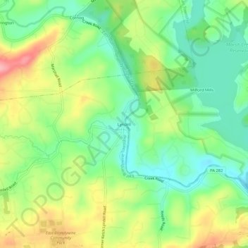
Nombre: Mapa topográfico Lyndell, altitud, relieve.
Altitud media: 137 m
Altitud mínima: 86 m
Altitud máxima: 213 m
Otros mapas topográficos
Haga clic en un mapa para ver su topografía, su altitud y su relieve.
Dorlan
United States > Pennsylvania > Chester County > East Brandywine Township
Dorlan, East Brandywine Township, Chester County, Pennsylvania, 19354, United States
Altitud media: 132 m
Bondsville
United States > Pennsylvania > Chester County > East Brandywine Township > Bondsville
Bondsville, East Brandywine Township, Chester County, Pennsylvania, 19372, United States
Altitud media: 150 m