
Haz una donación
Mapa topográfico Santa Ana Pueblo
Haga clic en el mapa para ver la altitud.
Haz una donación
Acerca de este mapa
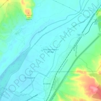
Nombre: Mapa topográfico Santa Ana Pueblo, altitud, relieve.
Altitud media: 1,558 m
Altitud mínima: 1,538 m
Altitud máxima: 1,638 m
Haz una donación
Otros mapas topográficos
Haga clic en un mapa para ver su topografía, su altitud y su relieve.
Bandelier National Monument
United States > New Mexico > Sandoval County
The monument is 50 square miles (130 km2) of the Pajarito Plateau, on the slopes of the Jemez volcanic field in the Jemez Mountains. Over 70% of the monument is wilderness, with over one mile of elevation change, from about 5,000 feet (1,500 m) along the Rio Grande to over 10,000 feet (3,000 m) at the peak of…
Altitud media: 2,130 m
Haz una donación
Kasha-Katuwe Tent Rocks National Monument
United States > New Mexico > Sandoval County
Altitud media: 1,852 m
Haz una donación
San Felipe Pueblo
United States > New Mexico > Sandoval County > San Felipe Pueblo
Altitud media: 1,640 m