
Mapa topográfico Rishton
Haga clic en el mapa para ver la altitud.
Rishton
Rishton is situated in an area of low moorland north east of Blackburn and north west of Accrington. Its elevation above sea level varies from 250 feet (76 m) in the east, where Norden Brook flows into the River Hyndburn, to 785 feet (239 m) on Rishton Height, north west of the town.
Acerca de este mapa
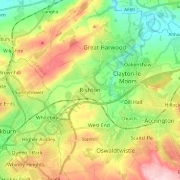
Nombre: Mapa topográfico Rishton, altitud, relieve.
Altitud media: 151 m
Altitud mínima: 57 m
Altitud máxima: 283 m
Otros mapas topográficos
Haga clic en un mapa para ver su topografía, su altitud y su relieve.
Oswaldtwistle Moor
United Kingdom > England > Lancashire > Hyndburn > Green Haworth > Cocker Brook
Altitud media: 300 m