
Mapa topográfico Mashpee Neck
Mapa interactivo
Haga clic en el mapa para ver la altitud.
Acerca de este mapa
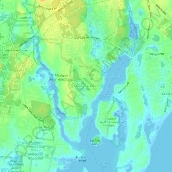
Nombre: Mapa topográfico Mashpee Neck, altitud, relieve.
Altitud media: 10 m
Altitud mínima: -4 m
Altitud máxima: 28 m
Otros mapas topográficos
Haga clic en un mapa para ver su topografía, su altitud y su relieve.
Santuit Pond
United States > Massachusetts > Barnstable County > Mashpee > Mashpee Neck > Pine Tree Corner
Santuit Pond, Pine Tree Corner, Mashpee Neck, Mashpee, Barnstable County, Massachusetts, United States
Altitud media: 15 m