
Haz una donación
Mapa topográfico Lupao
Haga clic en el mapa para ver la altitud.
Haz una donación
Lupao
Lupao belongs to the first type of climate in the Philippines. This type of climate has two (2) pronounced seasons: dry from the month of November to April and Wet during the rest of the year. This type of climate is typically hot, humid and tropical and is generally affected by the neighboring topography and the prevalent wind direction that varies within the year.
Haz una donación
Acerca de este mapa
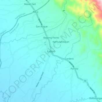
Nombre: Mapa topográfico Lupao, altitud, relieve.
Lugar: Lupao, Nueva Ecija, Central Luzon, Philippines (15.83701 120.85952 15.91701 120.93952)
Altitud media: 163 m
Altitud mínima: 89 m
Altitud máxima: 788 m
Haz una donación
Otros mapas topográficos
Haga clic en un mapa para ver su topografía, su altitud y su relieve.
Talavera
The municipality's terrain is relatively flat, with slope ranging from 0 to 3%. Due to the flat topography, the land is suited for agricultural, commercial or industrial development. It is bordered by Cabanatuan, Llanera, Muñoz, Aliaga, General Mamerto Natividad, Santo Domingo and San Jose.
Altitud media: 49 m
Haz una donación