
Mapa topográfico Eureka
Mapa interactivo
Haga clic en el mapa para ver la altitud.
Acerca de este mapa
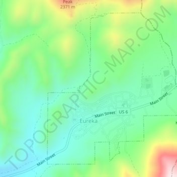
Nombre: Mapa topográfico Eureka, altitud, relieve.
Lugar: Eureka, Juab County, Utah, United States (39.94749 -112.12847 39.97063 -112.09986)
Altitud media: 2,048 m
Altitud mínima: 1,894 m
Altitud máxima: 2,396 m
Eureka is located in northern Juab County at 39°57′18″N 112°6′59″W / 39.95500°N 112.11639°W / 39.95500; -112.11639 (39.954974, -112.116364). It sits in the East Tintic Mountains at an elevation of 6,430 feet (1,960 m) above sea level. The northeast boundary of the city is the Utah County line, following the height of land. 7,828-foot (2,386 m) Packard Peak is to the north, while 8,048-foot (2,453 m) Godiva Mountain and 7,917-foot (2,413 m) Eureka Ridge are to the south.
Otros mapas topográficos
Haga clic en un mapa para ver su topografía, su altitud y su relieve.
Desert Mountain
United States > Utah > Juab County
Desert Mountain, Juab County, Utah, United States
Altitud media: 1,673 m
Topaz Mountain
United States > Utah > Juab County
Topaz Mountain, Juab County, Utah, United States
Altitud media: 1,895 m
Nephi
United States > Utah > Juab County > Nephi
Nephi, Juab County, Utah, 84648, United States
Altitud media: 1,651 m
Nephi
United States > Utah > Juab County
Nephi, Juab County, Utah, 84648, United States
Altitud media: 1,637 m