
Mapa topográfico Kennesaw
Mapa interactivo
Haga clic en el mapa para ver la altitud.
Acerca de este mapa
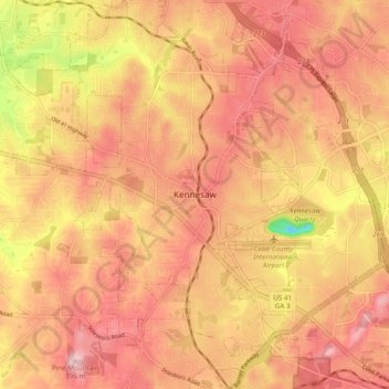
Nombre: Mapa topográfico Kennesaw, altitud, relieve.
Lugar: Kennesaw, Cobb County, Georgia, 30144, United States (33.98343 -84.65549 34.06343 -84.57549)
Altitud media: 318 m
Altitud mínima: 167 m
Altitud máxima: 393 m
Kennesaw is located in northwestern Cobb County, bordered by the city of Acworth to the northwest. Kennesaw Mountain is located southeast of the city limits in the battlefield park. Its summit is the highest point in the Atlanta metro area, at an elevation of 1,808 feet (551 m) above sea level. The city was renamed for the mountain.