
Gracias por apoyar a este sitio ❤️
Haz una donación
Haz una donación
Mapa topográfico Holes Bay
Haga clic en el mapa para ver la altitud.
Gracias por apoyar a este sitio ❤️
Haz una donación
Haz una donación
Acerca de este mapa
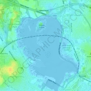
Nombre: Mapa topográfico Holes Bay, altitud, relieve.
Altitud media: 4 m
Altitud mínima: -3 m
Altitud máxima: 22 m
Gracias por apoyar a este sitio ❤️
Haz una donación
Haz una donación
Otros mapas topográficos
Haga clic en un mapa para ver su topografía, su altitud y su relieve.
Hamworthy Park
United Kingdom > England > Bournemouth, Christchurch and Poole > Poole
Altitud media: 2 m
Upton Heath Nature Reserve
United Kingdom > England > Bournemouth, Christchurch and Poole > Poole
Altitud media: 40 m
Island in the Stour
United Kingdom > England > Bournemouth, Christchurch and Poole > Poole > Merley
Altitud media: 28 m