
Mapa topográfico Attendorn
Mapa interactivo
Haga clic en el mapa para ver la altitud.
Acerca de este mapa
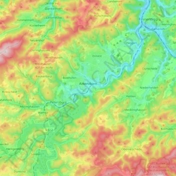
Nombre: Mapa topográfico Attendorn, altitud, relieve.
Lugar: Attendorn, Kreis Olpe, Noordrijn-Westfalen, 57439, Duitsland (51.07271 7.79579 51.17069 8.00401)
Altitud media: 384 m
Altitud mínima: 229 m
Altitud máxima: 630 m
Otros mapas topográficos
Haga clic en un mapa para ver su topografía, su altitud y su relieve.
Altenhundem
Duitsland > Noordrijn-Westfalen > Kreis Olpe > Lennestadt
Altenhundem, Lennestadt, Kreis Olpe, Noordrijn-Westfalen, 57368, Duitsland
Altitud media: 377 m
Kruberg
Duitsland > Noordrijn-Westfalen > Kreis Olpe > Olpe
Kruberg, Olpe, Kreis Olpe, Noordrijn-Westfalen, Duitsland
Altitud media: 440 m