Mapa topográfico Alpine
Haga clic en el mapa para ver la altitud.
Alpine
Located approximately 75 miles south of the Navajo Nation, Alpine was settled in 1876 by Anderson Bush, a European-American who built a log house there. He originally used it as a trading post known as "Fort Bush". Bush sold his holdings in 1879 to William Maxwell and Fred Hamblin, Mormon settlers who established the town as a Mormon community. They named the community for its lofty elevation.
Acerca de este mapa
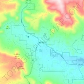
Nombre: Mapa topográfico Alpine, altitud, relieve.
Lugar: Alpine, Apache County, Arizona, 75920, United States (33.82839 -109.16466 33.86839 -109.12466)
Altitud media: 2,510 m
Altitud mínima: 2,411 m
Altitud máxima: 2,896 m
Otros mapas topográficos
Haga clic en un mapa para ver su topografía, su altitud y su relieve.


Window Rock
United States > Arizona > Apache County
Window Rock is categorized as being within the 6a USDA hardiness zone, meaning the average annual extreme minimum temperature is between −10 and −5 °F (−23 and −21 °C). The city is cooler than most of Arizona due to its high elevation.
Altitud media: 2,084 m