
Mapa topográfico Tinzaouten
Mapa interactivo
Haga clic en el mapa para ver la altitud.
Tinzaouten
Tin Zaouatine lies at an elevation of 630 metres (2,070 ft) in the far north-western part of the Adrar des Ifoghas mountain range, which lies mostly in Mali. A series of long, rocky ridges run from north-south to the west of the town.
Acerca de este mapa
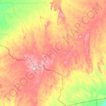
Nombre: Mapa topográfico Tinzaouten, altitud, relieve.
Lugar: Tinzaouten, Tinzaouaten District, In Guezzam, 11150, Algeria (18.96815 1.77632 21.90395 4.67314)
Altitud media: 578 m
Altitud mínima: 381 m
Altitud máxima: 909 m