
Mapa topográfico Utqiaġvik
Mapa interactivo
Haga clic en el mapa para ver la altitud.
Acerca de este mapa
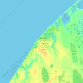
Nombre: Mapa topográfico Utqiaġvik, altitud, relieve.
Lugar: Utqiaġvik, North Slope, Alaska, 99273, United States (71.23029 -156.92450 71.34026 -156.63934)
Altitud media: 4 m
Altitud mínima: 0 m
Altitud máxima: 18 m
Despite the extreme northern location, temperatures at Utqiaġvik are moderated by the surrounding topography. The Arctic Ocean is on three sides, and flat tundra stretches some 200 miles (300 km) to the south. There are no wind barriers or protected valleys where dense cold air can settle or form temperature inversions in the lower atmosphere, as commonly happens in the interior between the Brooks and the Alaska ranges.
Otros mapas topográficos
Haga clic en un mapa para ver su topografía, su altitud y su relieve.
Wainwright
United States > Alaska > North Slope
Wainwright, North Slope, Alaska, 99782, United States
Altitud media: 5 m
Howe Island
United States > Alaska > North Slope
Howe Island, North Slope, Alaska, United States
Altitud media: 0 m
Deadhorse
United States > Alaska > North Slope
Deadhorse, North Slope, Alaska, United States
Altitud media: 15 m
Igloo Mountain
United States > Alaska > North Slope
Igloo Mountain, North Slope, Alaska, United States
Altitud media: 592 m
Prudhoe Bay
United States > Alaska > North Slope
Prudhoe Bay, North Slope, Alaska, 99734, United States
Altitud media: 10 m