
Mapa topográfico Forth and Clyde Canal Glasgow Spur Towpath
Mapa interactivo
Haga clic en el mapa para ver la altitud.
Acerca de este mapa
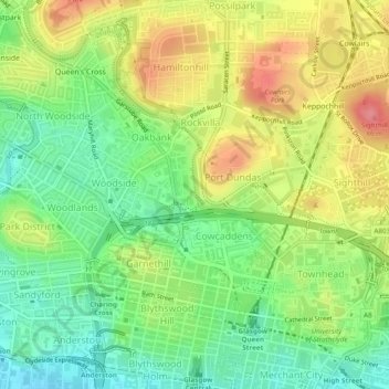
Nombre: Mapa topográfico Forth and Clyde Canal Glasgow Spur Towpath, altitud, relieve.
Altitud media: 43 m
Altitud mínima: 6 m
Altitud máxima: 88 m
Otros mapas topográficos
Haga clic en un mapa para ver su topografía, su altitud y su relieve.
Cairnhill Woods
United Kingdom > Scotland > Glasgow City > Glasgow
Cairnhill Woods, Netherton, Glasgow, Glasgow City, Scotland, United Kingdom
Altitud media: 39 m