
Mapa topográfico St Paul's Walden
Mapa interactivo
Haga clic en el mapa para ver la altitud.
Acerca de este mapa
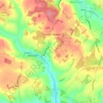
Nombre: Mapa topográfico St Paul's Walden, altitud, relieve.
Altitud media: 121 m
Altitud mínima: 79 m
Altitud máxima: 158 m
Otros mapas topográficos
Haga clic en un mapa para ver su topografía, su altitud y su relieve.
Hitchin
United Kingdom > England > Hertfordshire > North Hertfordshire
Hitchin, North Hertfordshire, Hertfordshire, England, SG5 1BB, United Kingdom
Altitud media: 91 m
Barley
United Kingdom > England > Hertfordshire > North Hertfordshire
Barley, North Hertfordshire, Hertfordshire, England, United Kingdom
Altitud media: 103 m
Therfield
United Kingdom > England > Hertfordshire > North Hertfordshire
Therfield, North Hertfordshire, Hertfordshire, England, United Kingdom
Altitud media: 122 m