
Haz una donación
Mapa topográfico Pahang
Haga clic en el mapa para ver la altitud.
Haz una donación
Pahang
The highest peak, Mount Tahan, reaches 2,187 m (7,175 ft) in elevation, which is also the highest point in the Peninsular Malaysia. The climate is temperate enough to have distinct temperature variations year round, and much of the highlands are covered with tropical rainforest. Pahang is home to Malaysia's two important national parks, Taman Negara and Endau-Rompin, both located in the north and south of the state respectively. These large primary rainforests are extensive, and are home to many rare or endangered animals, such as the tapir, kancil, tigers, elephants and leopards. Ferns are also extremely common, mainly due to the high humidity and fog that permeates the area. Popular hill resorts located along these main highland areas are Cameron Highlands, Genting Highlands, Fraser's Hill and Bukit Tinggi. The Cameron Highlands is home to extensive tea plantations and also a major supplier of legumes and vegetables to both Malaysia and Singapore. The largest FELDA's palm oil plantations in Malaysia are located in Jengka Triangle centred around the Bandar Tun Razak in Maran district.
Haz una donación
Acerca de este mapa
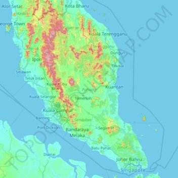
Nombre: Mapa topográfico Pahang, altitud, relieve.
Lugar: Pahang, Malaysia (1.06785 100.02710 6.18785 105.14710)
Altitud media: 90 m
Altitud mínima: -3 m
Altitud máxima: 2,127 m
Haz una donación
Otros mapas topográficos
Haga clic en un mapa para ver su topografía, su altitud y su relieve.
Cameron Highlands
Surveyed by the government geologist and explorer William Cameron in 1885, the outpost consists of three mukims (subdistricts), namely Ringlet, Tanah Rata and Ulu Telom. Its eight settlements are Ringlet, Tanah Rata (the administrative centre), Brinchang, the Bertam Valley, Kea Farm, Tringkap, Kampung Kuala…
Altitud media: 1,117 m
Haz una donación
Tioman Island
Local mythology claims that the island is the embodiment of the mighty dragon Sri Gumom. The dragon was on his way to visit his sister Gunung Linga (Lingin Peak). Still, the great Sri Rama forbade the meeting, and Sri Gumom was turned into a stone and fell into the deep sea where he now remains, frozen in…
Altitud media: 104 m
Haz una donación
Padang SMK Jengka Pusat
Malaysia > Pahang > Bandar Tun Abdul Razak (Bandar Jengka)
Altitud media: 75 m
Malaysia National Park
Taman Negara has a total area of 4,343 km2 and it is one of the world's oldest rainforests, estimated to be more than 130 million years old. Mount Tahan, Peninsular Malaysia's highest point with an elevation of 7,175 ft (2,187 m) above sea level, is within the park's boundaries. Taman Negara is an important…
Altitud media: 316 m
Haz una donación
Haz una donación
Haz una donación
Haz una donación
Haz una donación
Cameron Highlands
Surveyed by the government geologist and explorer William Cameron in 1885, the outpost consists of three mukims (subdistricts), namely Ringlet, Tanah Rata and Ulu Telom. Its eight settlements are Ringlet, Tanah Rata (the administrative centre), Brinchang, the Bertam Valley, Kea Farm, Tringkap, Kampung Kuala…
Altitud media: 1,117 m
Haz una donación
Tioman Island
Local mythology claims that the island is the embodiment of the mighty dragon Sri Gumom. The dragon was on his way to visit his sister Gunung Linga (Lingin Peak). Still, the great Sri Rama forbade the meeting, and Sri Gumom was turned into a stone and fell into the deep sea where he now remains, frozen in…
Altitud media: 104 m
Haz una donación
Haz una donación
Haz una donación
Haz una donación
Haz una donación
Sungai Ruan
Covering a total area of 9.7 square km at an average elevation of 227 meters above sea level, the village is surrounded by hills, forest and plantations with a population of about 6,000 people.
Altitud media: 142 m
Padang SMK Jengka Pusat
Malaysia > Pahang > Bandar Tun Abdul Razak (Bandar Jengka)
Altitud media: 75 m
Haz una donación
Cameron Highlands
Surveyed by the government geologist and explorer William Cameron in 1885, the outpost consists of three mukims (subdistricts), namely Ringlet, Tanah Rata and Ulu Telom. Its eight settlements are Ringlet, Tanah Rata (the administrative centre), Brinchang, the Bertam Valley, Kea Farm, Tringkap, Kampung Kuala…
Altitud media: 1,105 m
Haz una donación
Haz una donación
Haz una donación
Haz una donación
Haz una donación
Haz una donación
Haz una donación
Haz una donación
Cameron Highlands
Surveyed by the government geologist and explorer William Cameron in 1885, the outpost consists of three mukims (subdistricts), namely Ringlet, Tanah Rata and Ulu Telom. Its eight settlements are Ringlet, Tanah Rata (the administrative centre), Brinchang, the Bertam Valley, Kea Farm, Tringkap, Kampung Kuala…
Altitud media: 1,117 m
Haz una donación
Haz una donación
Haz una donación