
Gracias por apoyar a este sitio ❤️
Haz una donación
Haz una donación
Mapa topográfico Denver
Haga clic en el mapa para ver la altitud.
Gracias por apoyar a este sitio ❤️
Haz una donación
Haz una donación
Acerca de este mapa
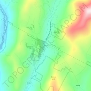
Nombre: Mapa topográfico Denver, altitud, relieve.
Altitud media: 594 m
Altitud mínima: 420 m
Altitud máxima: 919 m
Gracias por apoyar a este sitio ❤️
Haz una donación
Haz una donación
Otros mapas topográficos
Haga clic en un mapa para ver su topografía, su altitud y su relieve.
Gracias por apoyar a este sitio ❤️
Haz una donación
Haz una donación
Gracias por apoyar a este sitio ❤️
Haz una donación
Haz una donación
Gracias por apoyar a este sitio ❤️
Haz una donación
Haz una donación
Town of Bovina
United States > New York > Delaware County
The town has some of the highest uplands in the county. The elevation of the highest point exceeds 3,340 feet (1,020 m) above sea level, on an unnamed summit at the eastern corner of the town overlooking the Plattekill Mountain ski area in neighboring Roxbury.
Altitud media: 670 m
Gracias por apoyar a este sitio ❤️
Haz una donación
Haz una donación
Gracias por apoyar a este sitio ❤️
Haz una donación
Haz una donación
Gracias por apoyar a este sitio ❤️
Haz una donación
Haz una donación
Gracias por apoyar a este sitio ❤️
Haz una donación
Haz una donación
Gracias por apoyar a este sitio ❤️
Haz una donación
Haz una donación