
Mapa topográfico Daphne
Mapa interactivo
Haga clic en el mapa para ver la altitud.
Acerca de este mapa
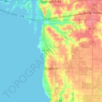
Nombre: Mapa topográfico Daphne, altitud, relieve.
Lugar: Daphne, Baldwin County, Alabama, 36526, United States (30.56903 -87.92237 30.67677 -87.84305)
Altitud media: 25 m
Altitud mínima: -2 m
Altitud máxima: 65 m
The topography of Daphne is quite consistent from a gently sloping sea level on the west to low rolling hills further east. Generally, the entire city lies no more than 150 feet above sea level. The land along the Daphne bay coast, like other land throughout the county, is rich with sandy-loam type soils.
Otros mapas topográficos
Haga clic en un mapa para ver su topografía, su altitud y su relieve.
Fort McDermott
United States > Alabama > Baldwin County > Spanish Fort
Fort McDermott, Spanish Fort, Baldwin County, Alabama, 36527, United States
Altitud media: 18 m
Fairhope
United States > Alabama > Baldwin County
Fairhope, Baldwin County, Alabama, 36533, United States
Altitud media: 17 m
Bridgehead
United States > Alabama > Baldwin County > Spanish Fort
Bridgehead, Spanish Fort, Baldwin County, Alabama, 36527, United States
Altitud media: 22 m
Gulf Shores
United States > Alabama > Baldwin County
Gulf Shores, Baldwin County, Alabama, 36542, United States
Altitud media: 4 m
Foley
United States > Alabama > Baldwin County
Foley, Baldwin County, Alabama, 36535, United States
Altitud media: 20 m
Orange Beach
United States > Alabama > Baldwin County
Orange Beach, Baldwin County, Alabama, United States
Altitud media: 5 m