
Mapa topográfico Issy-les-Moulineaux
Mapa interactivo
Haga clic en el mapa para ver la altitud.
Acerca de este mapa
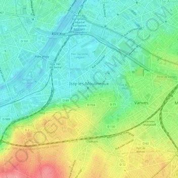
Nombre: Mapa topográfico Issy-les-Moulineaux, altitud, relieve.
Altitud media: 60 m
Altitud mínima: 26 m
Altitud máxima: 125 m
Otros mapas topográficos
Haga clic en un mapa para ver su topografía, su altitud y su relieve.
Le Plessis-Robinson
France > Ile-de-France > Hauts-de-Seine
Le Plessis-Robinson, Antony, Hauts-de-Seine, Ile-de-France, Metropolitan France, 92350, France
Altitud media: 146 m
Résidence Parc de Béarn
France > Ile-de-France > Hauts-de-Seine > Saint-Cloud
Résidence Parc de Béarn, Saint-Cloud, Arrondissement of Nanterre, Hauts-de-Seine, Ile-de-France, Metropolitan France, 92210, France
Altitud media: 71 m
Jardin de la Mairie
France > Ile-de-France > Hauts-de-Seine > Boulogne-Billancourt
Jardin de la Mairie, Centre Ville, Boulogne-Billancourt, Hauts-de-Seine, Ile-de-France, Metropolitan France, 92100, France
Altitud media: 52 m
Quartier Boieldieu
France > Ile-de-France > Hauts-de-Seine > Puteaux
Quartier Boieldieu, Puteaux, Arrondissement of Nanterre, Hauts-de-Seine, Ile-de-France, Metropolitan France, 92800, France
Altitud media: 52 m
Antony
France > Ile-de-France > Hauts-de-Seine
Antony, Hauts-de-Seine, Ile-de-France, Metropolitan France, 92160, France
Altitud media: 76 m
Residence Foch
France > Ile-de-France > Hauts-de-Seine > Garches
Residence Foch, Garches, Arrondissement of Nanterre, Hauts-de-Seine, Ile-de-France, Metropolitan France, 92380, France
Altitud media: 129 m
Bois-Colombes
France > Ile-de-France > Hauts-de-Seine
Bois-Colombes, Arrondissement of Nanterre, Hauts-de-Seine, Ile-de-France, Metropolitan France, 92270, France
Altitud media: 39 m
Quartier Mont-Valérien
France > Ile-de-France > Hauts-de-Seine > Suresnes
Quartier Mont-Valérien, Suresnes, Arrondissement of Nanterre, Hauts-de-Seine, Ile-de-France, Metropolitan France, 92150, France
Altitud media: 76 m
Levallois-Perret
France > Ile-de-France > Hauts-de-Seine
Levallois-Perret, Arrondissement of Nanterre, Hauts-de-Seine, Ile-de-France, Metropolitan France, 92300, France
Altitud media: 40 m
Montrouge
France > Ile-de-France > Hauts-de-Seine
Montrouge, Antony, Hauts-de-Seine, Ile-de-France, Metropolitan France, 92120, France
Altitud media: 76 m
Puteaux
France > Ile-de-France > Hauts-de-Seine
Puteaux, Arrondissement of Nanterre, Hauts-de-Seine, Ile-de-France, Metropolitan France, 92800, France
Altitud media: 52 m
Val Saint-Olaf
France > Ile-de-France > Hauts-de-Seine > Chaville > Val Saint-Olaf
Val Saint-Olaf, Chaville, Boulogne-Billancourt, Hauts-de-Seine, Ile-de-France, Metropolitan France, 92370, France
Altitud media: 128 m
Parc de Billancourt
France > Ile-de-France > Hauts-de-Seine > Boulogne-Billancourt
Parc de Billancourt, Rives de Seine, Boulogne-Billancourt, Hauts-de-Seine, Ile-de-France, Metropolitan France, 92100, France
Altitud media: 58 m
Clamart
France > Ile-de-France > Hauts-de-Seine > Clamart > Clamart
Clamart, Antony, Hauts-de-Seine, Ile-de-France, Metropolitan France, 92140, France
Altitud media: 104 m
Villeneuve-la-Garenne
France > Ile-de-France > Hauts-de-Seine > Villeneuve-la-Garenne
Villeneuve-la-Garenne, Arrondissement of Nanterre, Hauts-de-Seine, Ile-de-France, Metropolitan France, 92390, France
Altitud media: 33 m
Bagneux
France > Ile-de-France > Hauts-de-Seine > Bagneux
Bagneux, Antony, Hauts-de-Seine, Ile-de-France, Metropolitan France, 92220, France
Altitud media: 91 m
Bois de Boulogne
France > Ile-de-France > Hauts-de-Seine > Neuilly-sur-Seine
Bois de Boulogne, Neuilly-sur-Seine, Arrondissement of Nanterre, Hauts-de-Seine, Ile-de-France, Metropolitan France, 92200, France
Altitud media: 43 m
Courbevoie
France > Ile-de-France > Hauts-de-Seine
Courbevoie, Arrondissement of Nanterre, Hauts-de-Seine, Ile-de-France, Metropolitan France, 92400, France
Altitud media: 44 m
Meudon
France > Ile-de-France > Hauts-de-Seine
Meudon, Boulogne-Billancourt, Hauts-de-Seine, Ile-de-France, Metropolitan France, France
Altitud media: 132 m
Vanves
France > Ile-de-France > Hauts-de-Seine
Vanves, Boulogne-Billancourt, Hauts-de-Seine, Ile-de-France, Metropolitan France, 92170, France
Altitud media: 67 m
Vaucresson
France > Ile-de-France > Hauts-de-Seine
Vaucresson, Arrondissement of Nanterre, Hauts-de-Seine, Ile-de-France, Metropolitan France, 92420, France
Altitud media: 157 m
Nanterre
France > Ile-de-France > Hauts-de-Seine > Nanterre
Nanterre, Arrondissement of Nanterre, Hauts-de-Seine, Ile-de-France, Metropolitan France, 92000, France
Altitud media: 45 m
Boulogne-Billancourt
France > Ile-de-France > Hauts-de-Seine
Boulogne-Billancourt, Hauts-de-Seine, Ile-de-France, Metropolitan France, 92100, France
Altitud media: 43 m
Neuilly-sur-Seine
France > Ile-de-France > Hauts-de-Seine
Neuilly-sur-Seine, Arrondissement of Nanterre, Hauts-de-Seine, Ile-de-France, Metropolitan France, 92200, France
Altitud media: 41 m
Malakoff
France > Ile-de-France > Hauts-de-Seine
Malakoff, Antony, Hauts-de-Seine, Ile-de-France, Metropolitan France, 92240, France
Altitud media: 76 m