
Haz una donación
Mapa topográfico Reineberg
Haga clic en el mapa para ver la altitud.
Haz una donación
Reineberg
The Reineberg is a hill on the Wiehen ridge, south of the town of Lübbecke. With a height of 275.9 m above sea level it is, from a topographical point of view, not a particularly impressive eminence in this part of the Wiehen Hills, because, in the immediate vicinity are considerably higher summits, such as the 320 m high Heidbrink just under 1 km to the south. East of the Reinberg on the other side of a valley bottom rises the Heidkopf, west of the Meesenkopf, on the summit of which there was once a fortification. 230 metres southwest of the summit lies the Wittekind Spring, that had a certain importance for the garrison of the castle at the summit, but today is just a small pond by a rock outcrop at the edge of a track. The Reineberg, which is the local hill for the town of Lübbecke, owes its significance to the fact that, until 1723, the year of its demolition, Reineberg Castle (German: Burg Reineberg or Reineburg) stood here.
Haz una donación
Acerca de este mapa
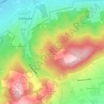
Nombre: Mapa topográfico Reineberg, altitud, relieve.
Altitud media: 181 m
Altitud mínima: 69 m
Altitud máxima: 310 m
Haz una donación
Otros mapas topográficos
Haga clic en un mapa para ver su topografía, su altitud y su relieve.