
Gracias por apoyar a este sitio ❤️
Haz una donación
Haz una donación
Mapa topográfico Kohima
Haga clic en el mapa para ver la altitud.
Gracias por apoyar a este sitio ❤️
Haz una donación
Haz una donación
Kohima
Kohima district is the land of the Angami Naga and Rengma Naga tribe. It is situated in the foothills of Japfu range located south of Kohima District (25°40′N 94°07′E / 25.67°N 94.12°E / 25.67; 94.12) and has an average elevation of 1,261 metres (4137 feet).
Gracias por apoyar a este sitio ❤️
Haz una donación
Haz una donación
Acerca de este mapa
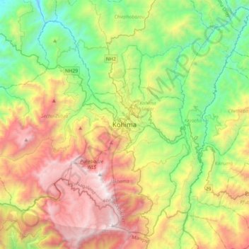
Nombre: Mapa topográfico Kohima, altitud, relieve.
Lugar: Kohima, Kohima Sadar, Kohima District, Nagaland, 797001, India (25.50188 93.94192 25.82188 94.26192)
Altitud media: 1,425 m
Altitud mínima: 430 m
Altitud máxima: 2,993 m
Gracias por apoyar a este sitio ❤️
Haz una donación
Haz una donación