
Haz una donación
Mapa topográfico Connersville
Haga clic en el mapa para ver la altitud.
Haz una donación
Connersville
Most of the town is located on the north bank of the west fork of the Whitewater River. The town is at modest elevation, a little over 800 feet (240 m) above sea level. The local area has nearly flat to gently rolling topography. The local region (and all of Fayette County and the state of Indiana) are part of the Eastern (U.S.) Broadleaf Forest Environment biome. Much of the surrounding Whitewater Valley vegetation would be classified as riparian woodland or gallery forest. There are 124 native tree species, including 17 varieties of oak, as well as black walnut, sycamore, and tulip tree (yellow poplar), the state tree. Fruit trees—apple, cherry, peach, and pear—are common. Common native mammals are the red fox, common cottontail, muskrat, raccoon, opossum, and several types of squirrel.
Haz una donación
Acerca de este mapa
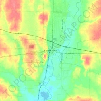
Nombre: Mapa topográfico Connersville, altitud, relieve.
Lugar: Connersville, Fayette County, Indiana, 47331, United States (39.60116 -85.18107 39.68116 -85.10107)
Altitud media: 269 m
Altitud mínima: 236 m
Altitud máxima: 313 m
Haz una donación