
Mapa topográfico Tinian Island
Mapa interactivo
Haga clic en el mapa para ver la altitud.
Acerca de este mapa
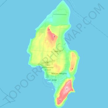
Nombre: Mapa topográfico Tinian Island, altitud, relieve.
Altitud media: 17 m
Altitud mínima: 0 m
Altitud máxima: 187 m
Tinian is about 5 nautical miles (9.3 km) southwest of Saipan, from which it is separated by the Saipan Channel. It has a land area of 39 square miles (100 km2), with its highest elevation on the Kastiyu plateau at 187 meters (614 ft). It is considerably flatter than Saipan. The island has limestone cliffs and caves. There is a variety of marine life and coral reefs surrounding the island. Its clear, warm waters are ideal for snorkeling, scuba diving and sport fishing.