
Mapa topográfico Hungry Hill
Mapa interactivo
Haga clic en el mapa para ver la altitud.
Acerca de este mapa
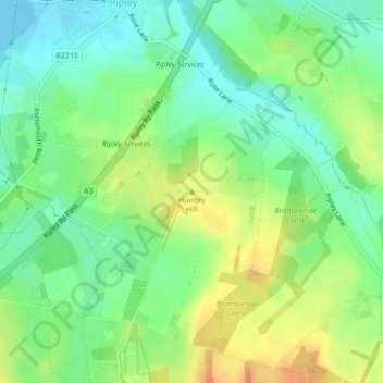
Nombre: Mapa topográfico Hungry Hill, altitud, relieve.
Altitud media: 40 m
Altitud mínima: 23 m
Altitud máxima: 63 m
Otros mapas topográficos
Haga clic en un mapa para ver su topografía, su altitud y su relieve.
Tunnel Hill
United Kingdom > England > Guildford
Tunnel Hill, Guildford, Surrey, South East, England, GU24 0BD, United Kingdom
Altitud media: 87 m