
Mapa topográfico County Meath
Mapa interactivo
Haga clic en el mapa para ver la altitud.
Acerca de este mapa
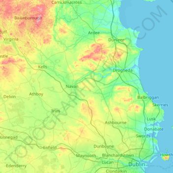
Nombre: Mapa topográfico County Meath, altitud, relieve.
Lugar: County Meath, Leinster, Ireland (53.38187 -7.34362 53.91751 -6.21291)
Altitud media: 64 m
Altitud mínima: -1 m
Altitud máxima: 323 m
Meath is largely flat and much of the county lies below 100 m (330 ft) above sea-level. The minor hills in the far west of the county at Loughcrew, and in the north at Carrickleck are the only upland areas of any significance. Slieve na Calliagh, at just 276 m (906 ft) in height, is the highest point in the county, making it the second lowest county top in Ireland. Carrickleck Hill, near the Cavan border, is the second highest peak in Meath, at 173 m (568 ft). The Hill of Tara is located south of Navan and, although just 155 m (509 ft) in height, is the most prominent feature in the local topography, commanding a panoramic view of the surrounding area.
Otros mapas topográficos
Haga clic en un mapa para ver su topografía, su altitud y su relieve.
Culleenatreen
Culleenatreen, Danesfort ED, Boyle Municipal District, County Roscommon, Connacht, Ireland
Altitud media: 65 m
Rathcormack
Rathcormack, Drumcliff South, Drumcliff West ED, Sligo Municipal Borough District, County Sligo, Connacht, F91 PY24, Ireland
Altitud media: 27 m
Newquay
Newquay, Abbey ED, West Clare Municipal District, County Clare, Munster, Ireland
Altitud media: 7 m
Kilrush
Kilrush, West Clare Municipal District, County Clare, Munster, Ireland
Altitud media: 22 m
Slaney
Slaney, Newtownbarry ED, The Municipal District of Enniscorthy, County Wexford, Leinster, Y21 E1T6, Ireland
Altitud media: 50 m
Galway City
Galway, Galway City, County Galway, Connacht, H91 YD86, Ireland
Altitud media: 26 m
Ballybrack
Ballybrack, Moville ED, Inishowen Municipal District, County Donegal, Ireland
Altitud media: 147 m
Ballyseedy Wood
Ballyseedy Wood, Ballyseedy ED, Tralee Municipal District, County Kerry, Munster, Ireland
Altitud media: 20 m
Kilkenny
Kilkenny, The Municipal District of Kilkenny City, County Kilkenny, Leinster, Ireland
Altitud media: 61 m
Johnstown
Johnstown, The Municipal District of Naas, County Kildare, Leinster, W91 Y3CP, Ireland
Altitud media: 97 m
Conaghy
Conaghy, Killeevan ED, Ballybay-Clones Municipal District, County Monaghan, Ulster, Ireland
Altitud media: 67 m
Glenfarne
Glenfarne, Glenfarn ED, Manorhamilton Municipal District, County Leitrim, Connacht, Ireland
Altitud media: 90 m
Sligo
Sligo, Sligo Municipal Borough District, County Sligo, Connacht, Ireland
Altitud media: 21 m
Dromore West
Dromore West, Ballymote-Tubbercurry Municipal District, County Sligo, Connacht, Ireland
Altitud media: 51 m
Morristown
Morristown, Rathmore ED, The Municipal District of Naas, County Kildare, Leinster, Ireland
Altitud media: 113 m
Moyglare
Moyglare, Rodanstown ED, The Municipal District of Ratoath, County Meath, Leinster, W23 RT91, Ireland
Altitud media: 66 m
Gort
Gort, Loughrea Municipal District, County Galway, Connacht, H91 R5F9, Ireland
Altitud media: 27 m
Cloonkeenkerrill
Cloonkeenkerrill, Colmanstown ED, Ballinasloe Municipal District, County Galway, Connacht, Ireland
Altitud media: 88 m
Colmanstown
Colmanstown, Killofin ED, West Clare Municipal District, County Clare, Munster, Ireland
Altitud media: 24 m
Summerhill
Summerhill, Summerhill ED, The Municipal District of Trim, County Meath, Leinster, Ireland
Altitud media: 86 m
Smithstown
Smithstown, Ballinlough ED, The Municipal District of Kells, County Meath, Leinster, Ireland
Altitud media: 121 m
Cordarragh
Cordarragh, Headford ED, Tuam Municipal District, County Galway, Connacht, Ireland
Altitud media: 20 m
Cahir
Cahir, The Municipal District of Cahir — Cashel, County Tipperary, Munster, Ireland
Altitud media: 58 m
Ballincollig
Ireland > County Cork > Cork
Ballincollig, Cork, County Cork, Munster, P31 TW88, Ireland
Altitud media: 62 m
Broadlough
Broadlough, Ardee Rural ED, The Municipal District of Ardee, County Louth, Leinster, Ireland
Altitud media: 34 m
Comeragh
Comeragh, The Municipal District of Comeragh, County Waterford, Munster, Ireland
Altitud media: 215 m
Adare
Ireland > County Limerick > The Municipal District of Adare — Rathkeale
Adare, The Municipal District of Adare — Rathkeale, County Limerick, Munster, Ireland
Altitud media: 12 m
Ballinaclogh
Ballinaclogh, Glenealy ED, The Municipal District of Wicklow, County Wicklow, Leinster, Ireland
Altitud media: 108 m
Lanesborough
Lanesborough, Ballymahon Municipal District, County Longford, Leinster, Ireland
Altitud media: 41 m
Lough Bane
Lough Bane, Crosskeys ED, The Municipal District of Kells, County Westmeath, County Meath, Leinster, Ireland
Altitud media: 130 m
Pembrokestown
Pembrokestown, Waterford City Metropolitan District, County Waterford, Munster, X91 R6CA, Ireland
Altitud media: 57 m
Ballivor
Ballivor, The Municipal District of Trim, County Meath, Leinster, Ireland
Altitud media: 67 m
Kilcurriv Eighter
Kilcurriv Eighter, Killower ED, Tuam Municipal District, County Galway, Connacht, Ireland
Altitud media: 48 m
Callanagh Lower
Callanagh Lower, Drumlumman ED, Ballyjamesduff Municipal District, County Cavan, Ulster, Ireland
Altitud media: 85 m
Curraghboy
Curraghboy, Rockhill Electoral Division, Athlone Municipal District, County Roscommon, Connacht, N37 EK20, Ireland
Altitud media: 69 m
Moorock
Moorock, Ballycumber ED, The Municipal District of Tullamore, County Offaly, Leinster, Ireland
Altitud media: 64 m
Gorteennakilla
Gorteennakilla, Youghalarra, The Municipal District of Nenagh, County Tipperary, Munster, Ireland
Altitud media: 57 m
Barnadown
Barnadown, Aghaviller, The Municipal District of Callan — Thomastown, County Kilkenny, Leinster, Ireland
Altitud media: 212 m