
Mapa topográfico Clarkston
Mapa interactivo
Haga clic en el mapa para ver la altitud.
Acerca de este mapa
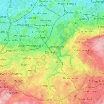
Nombre: Mapa topográfico Clarkston, altitud, relieve.
Altitud media: 94 m
Altitud mínima: 12 m
Altitud máxima: 210 m
Otros mapas topográficos
Haga clic en un mapa para ver su topografía, su altitud y su relieve.
Eaglesham
United Kingdom > Scotland > East Renfrewshire
Eaglesham, East Renfrewshire, Scotland, G76 0LG, United Kingdom
Altitud media: 172 m
Busby
United Kingdom > Scotland > East Renfrewshire
Busby, East Renfrewshire, Scotland, G76 8JZ, United Kingdom
Altitud media: 104 m
Newton Mearns
United Kingdom > Scotland > East Renfrewshire
Newton Mearns, East Renfrewshire, Scotland, G77 6EY, United Kingdom
Altitud media: 127 m
Dams to Darnley Country Park
United Kingdom > Scotland > East Renfrewshire > Barrhead
Dams to Darnley Country Park, Barrhead, East Renfrewshire, Scotland, United Kingdom
Altitud media: 77 m
Barrhead
United Kingdom > Scotland > East Renfrewshire
Barrhead, East Renfrewshire, Scotland, G78 1SD, United Kingdom
Altitud media: 93 m
Neilston
United Kingdom > Scotland > East Renfrewshire
Neilston, East Renfrewshire, Scotland, G78 3NJ, United Kingdom
Altitud media: 149 m
Uplawmoor
United Kingdom > Scotland > East Renfrewshire
Uplawmoor, East Renfrewshire, Scotland, G78 4AN, United Kingdom
Altitud media: 181 m
Thornliebank
United Kingdom > Scotland > East Renfrewshire > Thornliebank
Thornliebank, East Renfrewshire, Scotland, G46 7RX, United Kingdom
Altitud media: 59 m
Rouken Glen Park
United Kingdom > Scotland > East Renfrewshire > Thornliebank
Rouken Glen Park, Woodlands, Thornliebank, East Renfrewshire, Scotland, United Kingdom
Altitud media: 65 m
Giffnock
United Kingdom > Scotland > East Renfrewshire
Giffnock, East Renfrewshire, Scotland, G46 6XW, United Kingdom
Altitud media: 65 m