
Haz una donación
Mapa topográfico Münstertal
Haga clic en el mapa para ver la altitud.
Haz una donación
Münstertal
The Münstertal stretches from Staufen im Breisgau up into the Black Forest. It divides into several side valleys and extends in the direction of Belchen(Schwarzwald), via the district of Stohren towards the Schauinsland and via the Münsterhalde towards Badenweiler. The altitude of the Münstertal ranges from 380 m above sea level up to 1414 m on the summit of the Belchen, which represents a difference of 1060 meters.
Haz una donación
Acerca de este mapa
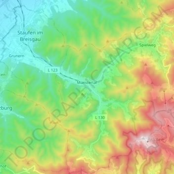
Nombre: Mapa topográfico Münstertal, altitud, relieve.
Altitud media: 643 m
Altitud mínima: 245 m
Altitud máxima: 1,407 m
Haz una donación
Otros mapas topográficos
Haga clic en un mapa para ver su topografía, su altitud y su relieve.
Dietenbach
Germany > Baden-Württemberg > Landkreis Breisgau-Hochschwarzwald > Kirchzarten (Kernort) > Kirchzarten
Altitud media: 482 m
Rheintal
Germany > Baden-Württemberg > Landkreis Breisgau-Hochschwarzwald > Müllheim im Markgräflerland
Altitud media: 424 m
Haz una donación