
Haz una donación
Mapa topográfico Wolfenweiler
Haga clic en el mapa para ver la altitud.
Haz una donación
Acerca de este mapa
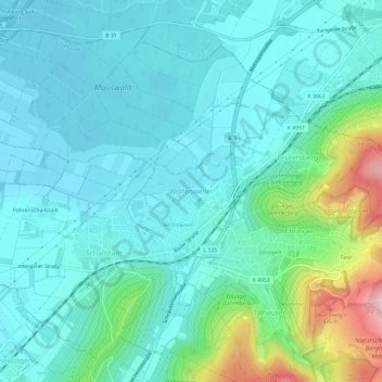
Nombre: Mapa topográfico Wolfenweiler, altitud, relieve.
Altitud media: 261 m
Altitud mínima: 209 m
Altitud máxima: 473 m
Haz una donación
Otros mapas topográficos
Haga clic en un mapa para ver su topografía, su altitud y su relieve.
79853
Germany > Baden-Württemberg > Landkreis Breisgau-Hochschwarzwald > Lenzkirch (Kernort)
Altitud media: 895 m
Neustadt im Schwarzwald
Germany > Baden-Württemberg > Landkreis Breisgau-Hochschwarzwald
Altitud media: 943 m
Bubenbach
Germany > Baden-Württemberg > Landkreis Breisgau-Hochschwarzwald
It lies at an altitude between 800 and 1130m above sea level in the Breg valley.
Altitud media: 988 m
Hartheim am Rhein
Germany > Baden-Württemberg > Landkreis Breisgau-Hochschwarzwald
Altitud media: 206 m
Haz una donación
Horben
Germany > Baden-Württemberg > Landkreis Breisgau-Hochschwarzwald
Horben is located to the south of the city of Freiburg and east of the Hexental valley on the western slope of the Schauinsland mountain range. It lies between the mountains of "Illenberg" (642 m [2,106 ft]) and "Eduardshöhe" (859 m [2,818 ft]). The area is the source of the Bohrer and Selzenbach creeks.…
Altitud media: 659 m
Haz una donación
Altglashütten
Germany > Baden-Württemberg > Landkreis Breisgau-Hochschwarzwald
Feldberg is a municipality in the district of Breisgau-Hochschwarzwald in Baden-Württemberg in southern Germany. It is located near the Feldberg, the highest summit in Baden-Württemberg. It comprises the settlements of Altglashütten, Neuglashütten, Falkau, Bärental, and Feldberg. At an elevation of 1,277…
Altitud media: 1,027 m
Raitenbuch
Germany > Baden-Württemberg > Landkreis Breisgau-Hochschwarzwald > Lenzkirch
Altitud media: 996 m
Haz una donación
Haz una donación
Unadingen
Germany > Baden-Württemberg > Landkreis Breisgau-Hochschwarzwald > Löffingen
Altitud media: 763 m
Burkheim
Germany > Baden-Württemberg > Landkreis Breisgau-Hochschwarzwald > Burkheim
Altitud media: 201 m
Haz una donación
Titisee-Neustadt
Germany > Baden-Württemberg > Landkreis Breisgau-Hochschwarzwald
Altitud media: 972 m
Horben
Germany > Baden-Württemberg > Landkreis Breisgau-Hochschwarzwald
Horben is located to the south of the city of Freiburg and east of the Hexental valley on the western slope of the Schauinsland mountain range. It lies between the mountains of "Illenberg" (642 m [2,106 ft]) and "Eduardshöhe" (859 m [2,818 ft]). The area is the source of the Bohrer and Selzenbach creeks.…
Altitud media: 659 m
Haz una donación
Lenzkirch
Germany > Baden-Württemberg > Landkreis Breisgau-Hochschwarzwald
Saig is a health resort on the southern flank of the Hochfirst, and at about 1,000m elevation is the highest community in the municipality. It has about 1,200 beds available for tourists.
Altitud media: 945 m
Breisach (Kernstadt)
Germany > Baden-Württemberg > Landkreis Breisgau-Hochschwarzwald > Breisach am Rhein > Hochstetten
Altitud media: 212 m
Gundelfingen
Germany > Baden-Württemberg > Landkreis Breisgau-Hochschwarzwald > Gundelfingen
Altitud media: 293 m
Haz una donación
Münstertal
Germany > Baden-Württemberg > Landkreis Breisgau-Hochschwarzwald
The Münstertal stretches from Staufen im Breisgau up into the Black Forest. It divides into several side valleys and extends in the direction of Belchen(Schwarzwald), via the district of Stohren towards the Schauinsland and via the Münsterhalde towards Badenweiler. The altitude of the Münstertal ranges from…
Altitud media: 643 m
Feldberg
Germany > Baden-Württemberg > Landkreis Breisgau-Hochschwarzwald
Feldberg is a municipality in the district of Breisgau-Hochschwarzwald in Baden-Württemberg in southern Germany. It is located near the Feldberg, the highest summit in Baden-Württemberg. It comprises the settlements of Altglashütten, Neuglashütten, Falkau, Bärental, and Feldberg. At an elevation of 1,277…
Altitud media: 1,037 m
Haz una donación
Grunern
Germany > Baden-Württemberg > Landkreis Breisgau-Hochschwarzwald > Staufen im Breisgau
Altitud media: 406 m