
Haz una donación
Mapa topográfico Horben
Haga clic en el mapa para ver la altitud.
Haz una donación
Horben
Horben is located to the south of the city of Freiburg and east of the Hexental valley on the western slope of the Schauinsland mountain range. It lies between the mountains of "Illenberg" (642 m [2,106 ft]) and "Eduardshöhe" (859 m [2,818 ft]). The area is the source of the Bohrer and Selzenbach creeks. Horben lies at an altitude above 400 m (1,300 ft) and is within the Southern Black Forest Nature park. Because of its proximity to the city of Freiburg new housing areas have been developed in the districts Langackern and Bohrer.
Haz una donación
Acerca de este mapa
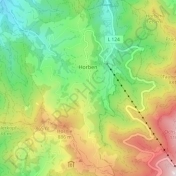
Nombre: Mapa topográfico Horben, altitud, relieve.
Altitud media: 659 m
Altitud mínima: 320 m
Altitud máxima: 1,170 m
Haz una donación
Otros mapas topográficos
Haga clic en un mapa para ver su topografía, su altitud y su relieve.
Dietenbach
Germany > Baden-Württemberg > Landkreis Breisgau-Hochschwarzwald > Kirchzarten (Kernort) > Kirchzarten
Altitud media: 482 m
Rheintal
Germany > Baden-Württemberg > Landkreis Breisgau-Hochschwarzwald > Müllheim im Markgräflerland
Altitud media: 424 m
Haz una donación