
Gracias por apoyar a este sitio ❤️
Haz una donación
Haz una donación
Mapa topográfico Lenzkirch
Haga clic en el mapa para ver la altitud.
Gracias por apoyar a este sitio ❤️
Haz una donación
Haz una donación
Lenzkirch
Saig is a health resort on the southern flank of the Hochfirst, and at about 1,000m elevation is the highest community in the municipality. It has about 1,200 beds available for tourists.
Gracias por apoyar a este sitio ❤️
Haz una donación
Haz una donación
Acerca de este mapa
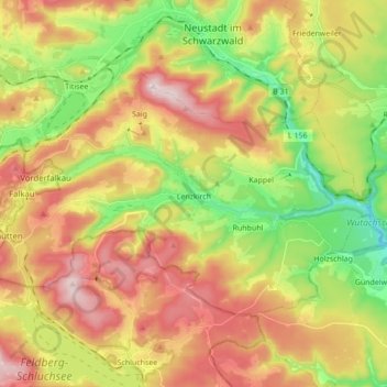
Nombre: Mapa topográfico Lenzkirch, altitud, relieve.
Altitud media: 945 m
Altitud mínima: 719 m
Altitud máxima: 1,192 m
Gracias por apoyar a este sitio ❤️
Haz una donación
Haz una donación
Otros mapas topográficos
Haga clic en un mapa para ver su topografía, su altitud y su relieve.
Dietenbach
Germany > Baden-Württemberg > Landkreis Breisgau-Hochschwarzwald > Kirchzarten (Kernort) > Kirchzarten
Altitud media: 482 m
Rheintal
Germany > Baden-Württemberg > Landkreis Breisgau-Hochschwarzwald > Müllheim im Markgräflerland
Altitud media: 424 m
Gracias por apoyar a este sitio ❤️
Haz una donación
Haz una donación