
Haz una donación
Mapa topográfico Feldberg
Haga clic en el mapa para ver la altitud.
Haz una donación
Feldberg
Feldberg is a municipality in the district of Breisgau-Hochschwarzwald in Baden-Württemberg in southern Germany. It is located near the Feldberg, the highest summit in Baden-Württemberg. It comprises the settlements of Altglashütten, Neuglashütten, Falkau, Bärental, and Feldberg. At an elevation of 1,277 m, the last is considered the highest village in Germany.
Haz una donación
Acerca de este mapa
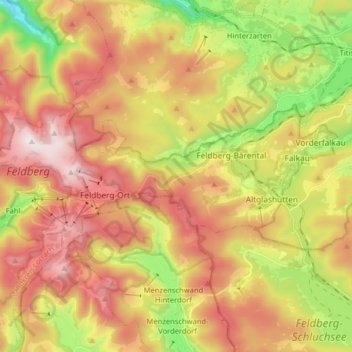
Nombre: Mapa topográfico Feldberg, altitud, relieve.
Altitud media: 1,037 m
Altitud mínima: 709 m
Altitud máxima: 1,448 m
Haz una donación
Otros mapas topográficos
Haga clic en un mapa para ver su topografía, su altitud y su relieve.
Dietenbach
Germany > Baden-Württemberg > Landkreis Breisgau-Hochschwarzwald > Kirchzarten (Kernort) > Kirchzarten
Altitud media: 482 m
Rheintal
Germany > Baden-Württemberg > Landkreis Breisgau-Hochschwarzwald > Müllheim im Markgräflerland
Altitud media: 424 m
Haz una donación