
Haz una donación
Mapa topográfico Tehri-Garhwal
Haga clic en el mapa para ver la altitud.
Haz una donación
Acerca de este mapa
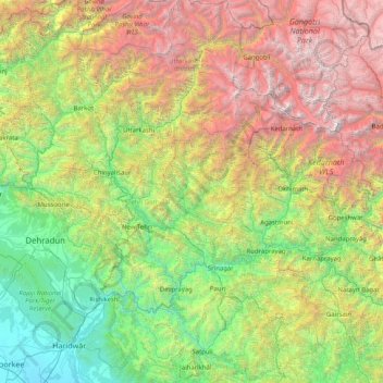
Nombre: Mapa topográfico Tehri-Garhwal, altitud, relieve.
Lugar: Tehri-Garhwal, Tehri Garhwal, Uttarakhand, 249125, India (29.80000 77.96667 31.20000 79.36667)
Altitud media: 2,339 m
Altitud mínima: 243 m
Altitud máxima: 7,106 m
Haz una donación
Otros mapas topográficos
Haga clic en un mapa para ver su topografía, su altitud y su relieve.
Haldwani
Haldwani is located at 29°13′N 79°31′E / 29.22°N 79.52°E / 29.22; 79.52, in the Nainital district on the right bank of the Gaula River. Geologically, Haldwani is settled on a piedmont grade (called Bhabhar) where the mountain rivers go underground to re-emerge in the Indo-Gangetic plain. The…
Altitud media: 526 m
Pauri Garhwal
The mountains of Khirsu offer views of the northern Himalayas and attract a large number of tourists. Located 19 kilometres (12 mi) away from Pauri at an altitude of 1,700 metres (5,600 ft), Khirsu is peaceful and free from pollution. There is the nearby ancient temple of Ghandiyal Devta. Accommodation is…
Altitud media: 958 m
Chamoli
The geology of the region shows that the Himalayas are amongst the youngest mountains in the world. During early Mesozoic times the land mass now covered by them was occupied by the great Tethys sea. The probable date of the commencement of the elevation of the Himalayas is about the close of the Mesozoic era,…
Altitud media: 3,712 m
Haz una donación