
Haz una donación
Mapa topográfico Pauri Garhwal
Haga clic en el mapa para ver la altitud.
Haz una donación
Pauri Garhwal
The mountains of Khirsu offer views of the northern Himalayas and attract a large number of tourists. Located 19 kilometres (12 mi) away from Pauri at an altitude of 1,700 metres (5,600 ft), Khirsu is peaceful and free from pollution. There is the nearby ancient temple of Ghandiyal Devta. Accommodation is available at the Tourist Rest House, Forest Rest House, and private hotel.
Haz una donación
Acerca de este mapa
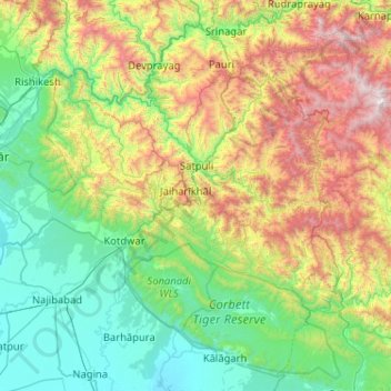
Nombre: Mapa topográfico Pauri Garhwal, altitud, relieve.
Lugar: Pauri Garhwal, Uttarakhand, India (29.43426 78.20209 30.26025 79.23187)
Altitud media: 958 m
Altitud mínima: 226 m
Altitud máxima: 3,068 m
Haz una donación
Otros mapas topográficos
Haga clic en un mapa para ver su topografía, su altitud y su relieve.
Mussoorie
India > Uttarakhand > Dehradun
Mussoorie is at an average altitude of 2,005 metres (6,578 ft). To the northeast are the Himalayan snow ranges, and to the south, the Doon Valley and Shiwalik ranges. The second highest point is the original Lal Tibba in Landour, with a height of over 2,275 m (7,464 ft). Mussoorie is popularly known as The…
Altitud media: 1,594 m
Dehradun
India > Uttarakhand > Dehradun
The city of Dehradun mainly lies in Doon Valley and is at a varying height from 410 m (1,350 ft) in Clement Town to above 700 m (2,300 ft) at Malsi which is 15 km (9.3 mi) from the city. However, the average elevation is 450 m (1,480 ft) above sea level. Malsi is the starting point of Lesser Himalayan Range…
Altitud media: 904 m
Haz una donación
Rudraprayag
India > Uttarakhand > Rudraprayag
Rudraprayag district is located at 30°17′N 78°59′E / 30.28°N 78.98°E / 30.28; 78.98. It has an average elevation of 895 metres (2,936 feet).
Altitud media: 1,140 m