
Haz una donación
Mapa topográfico Kreuztal
Haga clic en el mapa para ver la altitud.
Haz una donación
Kreuztal
The town's highest elevation is the mountain Hoher Wald at 655 m above sea level. The peak is however not open to the public, as it belongs to the Bundeswehr. Other mountains are the Hölzenberg 626 m above sea level, Kindelsberg 617.9 m above sea level (the town's landmark), the Martinshardt 616.1 m above sea level, the Ziegenberg 521 m above sea level, the Wilder Stein 478.9 m above sea level, die Rodenull 436 m above sea level, the Köpfchen 407.4 m above sea level, the Pfaffenberg 398.7 m above sea level, the Buberg, the Pühlsberg, the Krähenberg, the Altenhahn, the Löherhauberg, the Höhberg, the Rohberg, the Wolfshagen, the Mühlberg, the Mühlenkopf, the Kilgeshahn, the Siegerberg, the Kohlenberg, the Hohler Stein, the Dudeltätsch and the Heidlofsberg.
Haz una donación
Acerca de este mapa
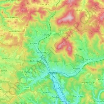
Nombre: Mapa topográfico Kreuztal, altitud, relieve.
Altitud media: 408 m
Altitud mínima: 256 m
Altitud máxima: 651 m
Haz una donación
Otros mapas topográficos
Haga clic en un mapa para ver su topografía, su altitud y su relieve.
Obernberg
Germany > North Rhine-Westphalia > Kreis Siegen-Wittgenstein > Bad Laasphe
Altitud media: 488 m
Rüppershausen
Germany > North Rhine-Westphalia > Kreis Siegen-Wittgenstein > Bad Laasphe
Altitud media: 497 m
NSG Erzebachtal
Germany > North Rhine-Westphalia > Kreis Siegen-Wittgenstein > Kreuztal > Fellinghausen
Altitud media: 329 m
Haz una donación
Heisberg
Germany > North Rhine-Westphalia > Kreis Siegen-Wittgenstein > Freudenberg
Altitud media: 338 m
Siegen
Germany > North Rhine-Westphalia > Kreis Siegen-Wittgenstein > Siegen
The city's total land area is roughly 115 km2 (44 sq mi). Its greatest east-west span is about 12 km (7 mi), and its greatest north-south span is about 12 km (7 mi). City limits are 48 km (30 mi) long. Siegen lies at a median elevation of 290 m (951 ft) above sea level. The city's greatest elevation is the…
Altitud media: 401 m