
Haz una donación
Mapa topográfico Zeppenfeld
Haga clic en el mapa para ver la altitud.
Haz una donación
Acerca de este mapa
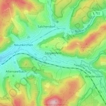
Nombre: Mapa topográfico Zeppenfeld, altitud, relieve.
Altitud media: 336 m
Altitud mínima: 251 m
Altitud máxima: 486 m
Haz una donación
Otros mapas topográficos
Haga clic en un mapa para ver su topografía, su altitud y su relieve.
Bad Laasphe
Germany > North Rhine-Westphalia > Kreis Siegen-Wittgenstein
The highest elevation in the municipal area rises to 694 m. It lies southwest of the main town at the outlying centre of Heiligenborn.
Altitud media: 464 m
Siegen
Germany > North Rhine-Westphalia > Kreis Siegen-Wittgenstein
The city's total land area is roughly 115 km2 (44 sq mi). Its greatest east-west span is about 12 km (7 mi), and its greatest north-south span is about 12 km (7 mi). City limits are 48 km (30 mi) long. Siegen lies at a median elevation of 290 m (951 ft) above sea level. The city's greatest elevation is the…
Altitud media: 346 m
Haz una donación
Dahlbruch
Germany > North Rhine-Westphalia > Kreis Siegen-Wittgenstein > Hilchenbach
Altitud media: 367 m
NSG Erzebachtal
Germany > North Rhine-Westphalia > Kreis Siegen-Wittgenstein > Kreuztal > Fellinghausen
Altitud media: 329 m
Kreuztal
Germany > North Rhine-Westphalia > Kreis Siegen-Wittgenstein
The town's highest elevation is the mountain Hoher Wald at 655 m above sea level. The peak is however not open to the public, as it belongs to the Bundeswehr. Other mountains are the Hölzenberg 626 m above sea level, Kindelsberg 617.9 m above sea level (the town's landmark), the Martinshardt 616.1 m above sea…
Altitud media: 408 m