
Haz una donación
Mapa topográfico Banggi Island
Haga clic en el mapa para ver la altitud.
Haz una donación
Banggi Island
Banggi Island (Malay: Pulau Banggi) is located within the Kudat Division of Sabah in Malaysia. With an area of 440.7 square kilometres, it is the largest island in Malaysia followed by Bruit Island, Langkawi Island and Penang Island. It is located off the northern coast of Sabah near Marudu Bay. The highest elevation on the island is Bukit Sinambung with height of 529 metres. As of 2016, it has an estimated population of 30,000. Banggi's largest settlement is Limbuak. In 2014, a new township was proposed to be built in the island. The island is also part of the gazetted area of Tun Mustapha Marine Park.
Haz una donación
Acerca de este mapa
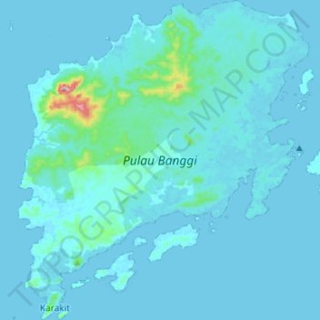
Nombre: Mapa topográfico Banggi Island, altitud, relieve.
Lugar: Banggi Island, Sabah, Malaysia (7.10037 117.05402 7.36281 117.29496)
Altitud media: 21 m
Altitud mínima: 0 m
Altitud máxima: 487 m
Haz una donación
Otros mapas topográficos
Haga clic en un mapa para ver su topografía, su altitud y su relieve.
Mount Kinabalu
Mount Kinabalu (Malay: Gunung Kinabalu, Dusun: Gayo Ngaran or Nulu Nabalu) is the highest mountain in Borneo and Malaysia. With an elevation of 13,435 feet (4,095 m), it is third-highest peak of an island on Earth, and 20th most prominent mountain in the world by topographic prominence. The mountain is located…
Altitud media: 3,567 m
Haz una donación
Haz una donación
Haz una donación
Mount Kinabalu
Low's Peak can be climbed by a person in good physical condition without mountaineering equipment on the main route. However, climbers must be accompanied by accredited guides at all times due to national park regulations and the risk of experiencing altitude sickness.
Altitud media: 3,567 m
Haz una donación
Haz una donación
Haz una donación
Haz una donación
Haz una donación
Haz una donación
Tambunan
Tambunan (Malay: Pekan Tambunan) is the capital of the Tambunan District in the Interior Division of Sabah, Malaysia. Its population was estimated to be around 35,667 in 2010. It is located 80 kilometres east of the state capital, Kota Kinabalu (to which is connected by the Kota Kinabalu-Tambunan-Keningau…
Altitud media: 697 m
Haz una donación
Haz una donación
Haz una donación
Haz una donación
Haz una donación
Haz una donación
Haz una donación
Haz una donación
Haz una donación
Haz una donación
Haz una donación
Haz una donación
Haz una donación
Haz una donación
Haz una donación
Haz una donación