
Haz una donación
Mapa topográfico Cabresto Lake
Haga clic en el mapa para ver la altitud.
Haz una donación
Acerca de este mapa
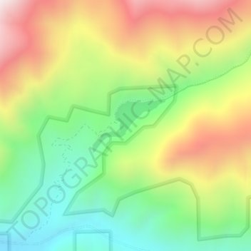
Nombre: Mapa topográfico Cabresto Lake, altitud, relieve.
Lugar: Cabresto Lake, Taos County, New Mexico, United States (36.74439 -105.50237 36.75019 -105.49261)
Altitud media: 2,933 m
Altitud mínima: 2,547 m
Altitud máxima: 3,433 m
Haz una donación
Otros mapas topográficos
Haga clic en un mapa para ver su topografía, su altitud y su relieve.
Haz una donación
Tres Piedras
United States > New Mexico > Taos County
Tres Piedras is located approximately 30 miles northwest of Taos, and west of the Rio Grande on U.S. Route 64. At approximately 8,000 feet (2,400 m) in altitude, it is located within the southern portion of the San Juan Range of the Rocky Mountains. Tres Piedras is on the western edge of a sagebrush plain,…
Altitud media: 2,476 m
Sipapu
United States > New Mexico > Taos County
Sipapu Ski & Summer Resort, also known simply as Sipapu, is a moderately sized ski resort in Taos County, New Mexico. It is home to New Mexico's longest ski season, from November to April. The peak elevation is 9,255 ft (2,821 m). There are 41 trails and 6 lifts. Other facilities include 4 terrain parks, golf,…
Altitud media: 2,754 m
Haz una donación
Haz una donación